
The Petrified Forest National Park and Meteor Crater, Arizona
The center of Meteor Crater as seen from a viewing platform on the rim of the crater
As an elementary school geography teacher, I had the privilege of instructing 4th and 5th-grade students about numerous wonders of the United States. Some of my greatest joys in retirement have been the opportunities to visit the actual locations I had discussed with my students in the classroom. Many of the attractions we studied were situated in the western region of the United States.
Table of contents: ()

First Encounter with Two Famous Sites
Recently, I embarked on a trip to northern New Mexico and southern Colorado, and during my journey, I traveled close to the Petrified Forest National Park and Meteor Crater. I had spoken about these sites on numerous occasions, yet I had never had the opportunity to visit them before. I was thrilled to explore both locations and had high hopes. What I did not foresee was the extent to which these sites surpassed my expectations!
Location and Ownership
Both locations, the Petrified Forest National Park and Meteor Crater, are situated in the northwestern region of Arizona. While they may seem to be in close proximity, a distance of approximately 95 miles separates the two sites. Fortunately, both locations are conveniently located near Interstate 40, providing easy access by vehicle.

The rim and sloping sides of Meteor Crater
A key difference that distinguishes the two sites is that Meteor Crater is privately owned by the Barringer Family, the descendants of the person who proposed that a meteor impact created the crater. In contrast, the Petrified Forest National Park is managed by the National Park Service, an agency under the Department of the Interior of the United States. During my journey, the first site I visited was the Meteor Crater National Landmark.
Meteor Crater

Approaching Meteor Crater from Meteor Crater Road
A Landmark of Global Importance
Meteor Crater, also known as Barringer Crater, is situated approximately 7 miles (60 km) east of Flagstaff and 18 miles (29 km) west of Winslow, within a high desert climate in northern Arizona. My familiarity with this location stems from the fact that it is the largest intact impact crater on our planet. Students consistently express interest in exploring the formation of both the Earth and the Moon, and they are intrigued by the stark differences in appearance between these two celestial bodies.
While they comprehend the concept of impacts from meteors originating in space, they often ponder why there are relatively few such occurrences on Earth. It is easy to draw their attention to Meteor Crater, as it resembles the craters we see on the Moon. This serves as tangible evidence that, at one point, the Earth also experienced meteor impacts similar to those on our Moon. For me, this represented an extraordinary opportunity. Despite having taught about this site for 37 years, I had never had the opportunity to witness it firsthand. At last, I was going to experience what made it so special.

The bowl of Meteor Crater as seen from inside the Visitor’s Center
Arrival and First Impressions
Reaching Meteor Crater was straightforward due to the construction of an exit from Interstate 40, along with a connecting road named Meteor Crater Road that leads directly to the Visitor’s Center. The high desert landscape in this region is predominantly flat, featuring sparse vegetation. In the distance, larger mountains are visible, alongside some smaller conical volcanic formations nearby. I anticipated seeing the towering walls of the crater as I approached the site; however, what I primarily observed was flat land with a rounded hill appearing in the distance.
Arriving around midday in late June, I found the weather was agreeable, but upon exiting my vehicle, I encountered strong winds with gusts reaching up to 50 mph. I made my way to the Visitor’s Center, paid the entrance fee, and engaged in conversation with members of the guiding staff. Everyone was exceptionally friendly and provided helpful information.

The Visitor Center at Meteor Crater
Exploring the Visitor Center
I scheduled my visit to coincide with the complimentary guided tour; however, I found out that all afternoon tours had been canceled due to strong winds. There were worries about the risk of visitors slipping and falling at the edge of the crater. After I visited the crater, I realized how such accidents could easily happen. The Visitor Center included a museum, an educational film, a cafeteria, a gift and mineral shop, as well as several interactive exhibits. I spent some time exploring the museum and viewing the film about the formation of the crater.
To my astonishment, it took many years for scientists to verify that it was indeed an impact crater. It was only after they reached a consensus on its formation that they acquired significant knowledge about it. Furthermore, I took part in a special presentation and a question-and-answer session led by the guiding staff to compensate for the lack of a guided outdoor tour. After all these activities, I felt ready to step outside onto the protected walkways to observe the crater.

A viewing platform inside the rim of Meteor Crater
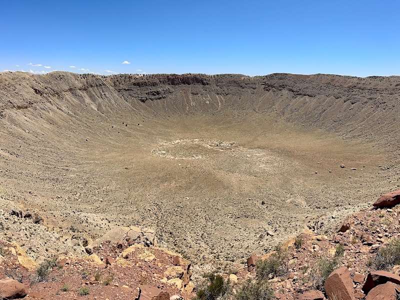
Viewing the Crater
My initial response was that it was far more impressive than I had anticipated. I had expected it to resemble a large indentation in the Earth, but it actually appeared similar to what I had imagined a deep lunar crater would look like. The crater itself measures approximately 3,900 feet (1,200 m) in diameter and is about 560 feet (170 m) deep. It is believed that since the formation of the crater, the rim crest has subsided by approximately 50 – 65 feet (15 – 20 m) due to natural erosion. At present, the rim stands 148 ft (45 m) above the adjacent plains.

An exhibit to honor the astronauts who trained for lunar landings at Meteor Crater
I spent around 45 minutes traversing the paved pathways from the Visitor’s Center down the slope of the crater. I captured numerous photographs and engaged in conversation with several other visitors. Overall, I was captivated by the starkness and the beauty of the geological formation.

Holsinger Meteorite, the largest piece of the Canyon Diablo meteorite that formed Meteor Crater
Wrapping Up the Visit
After approximately 45 minutes of contending with the strong winds and sunlight, I made my way back up the paths to the Visitor Center. Inside, I encountered the Holsinger Meteorite, the largest piece of the Canyon Diablo meteorite that formed Meteor Crater, weighing 1,409 lb (639 kg). I engaged in conversation with one of the guides regarding Daniel M. Barringer and the Barringer family, who obtained the land by filing mining claims and later purchasing it along with its surrounding areas in the 1920s.
Following a few more photographs and a brief visit to the gift shop, it was time for me to return to the car and proceed east on the Interstate. In total, I dedicated around 2 hours to my visit. Overall, it was an exceptional road trip stop!
Petrified Forest National Park

An antique car marking the location of historic Route 66
Overnight in Holbrook
My next destination was the Petrified Forest National Park. Given the time of day, I decided to postpone my visit to the park until the following morning. The park operates daily from 8 am to 5 pm, with extended hours available from spring through fall. Both north and south entrances are secured with gates, preventing visitors from arriving early or lingering after hours. Wilderness camping is permitted, although permits are necessary.
I spent the night in Holbrook, Arizona, which is one of those quirky towns commonly found near the entrances of National Parks in the United States. Historic Route 66 runs through a portion of Holbrook, providing the town with the sense of nostalgia associated with the Mother Road. Although the majority of shops were closed when I arrived in the early evening, I found some enjoyment in visiting the picturesque Wigwam Motel, frequently highlighted in narratives about Route 66, as well as a local Dairy Queen.

A petrified log along the Crystal Forest Trail
Planning the Park Visit
As I was on a road trip and needed to arrive in northern New Mexico by evening, I intended to allocate approximately 2.5 to 3 hours for a visit to the Petrified Forest National Park. To optimize my time, I chose to enter through the southern entrance along Arizona Route 180, and then drive along the main road through the park to reach the northern entrance near Interstate 40.
I had two motivations for this itinerary. Given my limited time within the park, my foremost interest was in observing the petrified wood sites situated in the southern part of the park. Additionally, the route from south to north would serve as the most efficient path for my journey to northern New Mexico after I completed my visit to the park. I arrived at the park entrance at 7:50 am and found myself third in line, awaiting the opening of the automatic gate.

Eroded badlands as seen from Hamilili Point in the southern section of the Petrified Forest National Park
History and Scope of the Park
The Petrified Forest was established as a national park in 1962, having previously been recognized as a national monument since 1906. The majority of the park stretches well beyond Park Road, which serves as the primary thoroughfare through the area, covering an expanse of 346 square miles. Nearly one-third of the park is classified as wilderness. Besides its numerous deposits of petrified wood, the park also encompasses a portion of the Painted Desert, a colorful desert badlands region that extends to the eastern edge of Grand Canyon National Park.

Petrified logs along the Crystal Forest Trail
Ancient Origins of Petrified Wood
I visited the park mainly to see petrified logs, the fossilized remnants of an ancient Triassic rainforest that existed approximately 225 million years ago. The trees, which were buried beneath sediment and debris, were deprived of oxygen and gradually decomposed. Over time, minerals such as silica from volcanic ash were absorbed into the porous wood. Ultimately, these minerals crystallized within the wood’s cellular structure, replacing the organic material.
Geologists believe that approximately 60 million years ago, tectonic movements raised this layer, now known as the Colorado Plateau, exposing this section of the Earth to wind and water erosion. Eventually, these natural forces uncovered the petrified logs and exposed the vibrant layers of soil.
Preservation and Theft Issues
Beginning in the mid-19th century, roads were constructed through the region that would later become the park. The appeal of the fossils and the surrounding landscape stimulated tourism and drew in mineral prospectors. Regrettably, before the park’s designation as a protected area, there was considerable extraction of fossils and unique petrified wood remnants.
According to published reports, the theft of petrified wood continues to be a major issue at Petrified Forest National Park even today, despite ongoing efforts to discourage the practice. Although various measures have been put in place, such as signage, pledges, and volunteer initiatives, it is estimated that 12 tons of petrified wood still vanish from the park annually.

First Impressions of the Park
While en route to the park’s entrance, I observed a considerable number of shops and businesses selling large pieces of petrified logs to visitors. My initial thought was, “Where did all this fossilized wood in these shops originate?” I am certain that there are locations beyond the park’s boundaries in the adjacent region where petrified wood can be discovered, yet it prompted me to ponder whether, given the abundant purchasing options available outside the park, “Were there still many remains within the National Park?” It also crossed my mind that perhaps a large number of the valuable fossils had been taken away long ago and sold to mineral collectors.
Shortly after 8 am, I entered the park and halted at the entrance hut for vehicles. The ranger recommended that I purchase an “America the Beautiful” Senior Pass for $20, which would grant me access to more than 2000 federal recreation areas, including National Parks, for a year. This seemed like an excellent bargain! Before long, I was on my way towards the Rainbow Forest Museum, the visitor center for the southern region of the park.

The entrance to the Blue Forest Trail on the Blue Mesa
Enhancing the Experience with an Audio Tour
A valuable resource that can substantially enhance a visit to the Petrified Forest National Park is a complimentary audio tour available on the park’s website. The tour is designed for both directions of travel, making it user-friendly regardless of the entrance you choose to access the park. I utilized the audio tour on my mobile device and listened to it while driving between various stops. I discovered that the historical and geological insights greatly enriched my experience and assisted me in understanding what to observe at each site before exiting my vehicle.

The entrance to the Rainbow Forest Museum Visitors Center
Rainbow Forest Museum
After a brief stop at the National Park entrance sign, I quickly arrived at the parking area for the Rainbow Forest Museum. The Rainbow Forest is the area of the park that was the original Petrified Forest, designated by President Theodore Roosevelt as a national monument in 1906. A modest tar-paper shack that was built as a ranger station eventually transformed into the stone Administrative Building that stands today.
The museum, located in the original headquarters of the park, was established to showcase paleontological exhibits, a diorama, a bookstore, and a visitor center for the southern part of the park. From the museum, guests can access the Giant Logs and Long Logs Trails. Additionally, the Agate House, a pueblo built from petrified wood, is located nearby.

Pieces of petrified wood along the Giant Logs Trail
Giant Logs and Long Logs Trails
Following a brief visit to the museum, I was eager to observe some petrified wood, prompting me to proceed to the Giant Logs Trail. Petrified wood is essentially large pieces of quartz that look like sections of trees. Each specimen is, in fact, a giant crystal, yet they appear distinct due to impurities in the quartz, including iron, carbon, and manganese, which can produce a spectrum of colors. What I encountered were stones that resembled tree logs. In numerous instances, the hues of the crystals mirrored those of a tree, but as I looked closely, I could discern crystals of clear quartz, purple amethyst, yellow citrine, and smoky quartz. The visual impact was astounding!

Petrified logs with quartz crystals
I also observed that it appeared as though someone had taken the majority of the logs and sliced them into sections of wood. This occurred naturally because the quartz contained within the petrified wood was both hard and brittle. The logs easily fractured when subjected to subterranean stress. The fractures were so precise they looked as if someone had cut them with a chainsaw.

A large petrified tree along the Long Logs Trail
I was struck by the numerous large pieces of petrified wood located along the Giant Logs Trail, as well as the wealth of specimens present on the Long Logs Trail. Throughout my visit to these trails, I encountered very few other visitors. I had a similar experience at the Crystal Forest, Jasper Forest, and Agate Bridge. Each of these sites showcases distinct deposits of petrified wood within an eroding landscape. The Agate Bridge itself is a petrified log that once served as a bridge.

The petrified Agate Bridge
Most of the trails featuring petrified wood were situated adjacent to the main park road. Parking spaces were abundant, and at the final three locations, I discovered that I was the only person walking the trails and capturing photographs. In the golden light of the morning sun, the distinct feeling of being the sole individual amidst such peace and beauty created a memory that I will forever cherish.

Eroded badlands viewed from the Blue Mesa
Blue Mesa and Geological Formations
Although I was aware that I was spending more time in the park than I anticipated, I believed it would be a missed opportunity to overlook the significant sites in the northern section of the park. I also recognized that it was unlikely I would have another opportunity to enjoy the park in such a tranquil manner. My next stop, the Blue Mesa, shifted my focus from the petrified wood features of the park to the vibrant geological formations that define the northern region of the park.

Hoodoos and eroded badlands at the edges of the Blue Mesa
Reaching the Blue Mesa necessitates taking a spur road situated approximately halfway through the National Park. Visitors ascend to the summit of the mesa and then witness eroded cliffs, badlands, hoodoos, and unique rock formations from various scenic overlooks. Each viewpoint offers a distinct perspective of the blue, purple, gray, and peach banded badlands. Sporadic petrified wood deposits can be observed between the different layers of the terrain. One of the final stops along the one-way road features the Blue Forest Trail, which permits hikers to walk across the top of some formations and subsequently descend into the valley nestled between the eroded hills.

The eroded valleys of the Blue Forest
Teepees, Newspaper Rock, and Puerto Pueblo
As I journeyed further north, I came across conical hills characterized by vibrant banded layers, referred to as teepees due to their similarity to Native American shelters. Although teepees were not part of the local culture, the term has endured through the years. I stopped to capture some photographs from a distance before proceeding to Newspaper Rock, a site featuring a collection of rock faces adorned with over 650 petroglyphs. The formation is best viewed from above, but without binoculars, the petroglyphs were challenging to see.

The teepee hill formations of Petrified Forest National Park
Following this, I made a quick stop at Puerto Pueblo, where a series of dwellings once occupied by the ancestral Puebloan people can be found. Despite the site’s considerable historical significance, only the foundations of the original structures remain. I did not stay long, as it was hard to imagine how this area might have appeared and functioned. This location was the only place where I encountered a larger group of park visitors.

A hill formed by banded layers of soil
Painted Desert Overlooks
At this point, I realized that I was significantly behind schedule, yet I still wanted to explore the Painted Desert. I made a brief stop at the site featuring the remnants of an old car, which marked the intersection of historic Route 66 with the park. Following this, I visited several scenic viewpoints where I could admire the views of the Painted Desert, the badlands area famous for its stunning red and lavender rock formations.

The Painted Desert as seen from Lacey Point
The desert was named by Spanish explorer Francisco Vázquez de Coronado and his expedition during their 1540 quest to find the Seven Cities of Cibola. I must confess, I did not spend much time in this part of the park, but I did stop at Lacey Point, Nizhoni Point, Kachina Point, and the Painted Desert Inn to appreciate the landscape and take some photographs.

The conical hills of the Blue Forest badlands
Visitor Encounters
On two occasions, while I was returning to my vehicle, I was approached by visitors who mentioned they were only in the area for a brief time and wished to view the petrified logs. I provided them with both good and bad news. I assured them that there were indeed excellent locations to observe petrified logs, making the visit worthwhile. However, the bad news was that these sites were located approximately 20 miles south along the main park road. Additionally, since they were heading east, they would need to travel another 20 miles back north to access Interstate 40. Had they conducted some prior research, they could have utilized the southern entrance and integrated the park into their eastward journey.

The entrance to the historic Painted Desert Inn
Painted Desert Inn
My final destination was the Painted Desert Inn, located on a mesa that overlooks the expansive and colorful Painted Desert. The inn began as a modest tourist lodge during the park’s early years, but in 1935, the National Park Service acquired the inn along with the adjacent land and employed the Civilian Conservation Corps (CCC) to carry out much of the renovation work.

The lunchroom cafe in the historic Painted Desert Inn
Over time, the inn experienced periods of opening and closing due to the changing priorities brought about by World War II. Ultimately, in 1947, it came under the ownership of the esteemed Fred Harvey Company, a firm with significant connections to the history of the Southwest, railroads, and tourism. His accommodations for travelers in National Parks and along the railroad routes were renowned for their comfort and quality.

A sitting room and dining area in the historic Painted Desert Inn
Under the management of the Fred Harvey Company, the Desert Inn provided meals, souvenirs, and accommodations for travelers on Route 66. It was also favored by locals as a venue for meetings and special occasions. Over time, the inn experienced a decline and ultimately closed its doors in 1963.

The rear of the Painted Desert Inn and pathway to Kachina Point
After being scheduled for demolition, a public initiative successfully preserved the building, which was included in the National Register of Historic Places by the National Park Service in 1976. The Secretary of the Interior acknowledged the inn’s historical importance by designating it a National Historic Landmark in 1987. In 2006, the Painted Desert Inn reopened after a comprehensive restoration. The inn now resembles its appearance in 1949 and functions as a historic site where visitors can purchase snacks, souvenirs, and explore the historic rooms.

Newspaper Rock featuring over 650 petroglyphs
I dedicated thirty minutes to exploring the inn and appreciating the historic interior design. I imagined that at some point, it must have been a remarkable experience to stay in a hotel with views of the Painted Desert. Given that the rooms, along with the communal areas and dining spaces, were arranged as travelers would have encountered them, I felt as though I had traveled back in time. I was especially impressed by the vividly illustrated mountain lion petroglyph displayed within the inn, as well as the decorations that incorporated Native American themes. The Painted Desert Inn is an essential stop when visiting the park. As I approached noon, I had to leave and, unfortunately, pass by the Painted Desert Visitors Center on my way to Interstate 40.
Lessons from the Journey
My initial impression of both locations was that they significantly exceeded my expectations. I felt that I allocated the appropriate amount of time at Meteor Crater, but I should have dedicated at least half a day to the Petrified Forest. I initially believed I could explore it in approximately 2 1/2 hours, but I hurried to visit the main attractions in just under 4 hours, which left me without the opportunity to stop at the Painted Desert Visitors Center. Both of these locations are situated between Flagstaff, Arizona, and Albuquerque, New Mexico, and there are additional attractions nearby, such as the New Mexico Badlands, Four Corners Region, and the Grand Canyon, making them ideal for an extensive road trip.

The Painted Desert as seen from Kachina Point
Travel Tips
If you are traveling east or west along Interstate 40, it is advisable to plan a visit to one or both of these sites. Consideration should be given to the direction from which you approach the Petrified Forest. If you are traveling east to west, you should enter from the north. Conversely, if you are traveling from west to east, you should enter from the south. The Petrified Forest offers a more enriching experience if you take the time to hike some of the trails.
If you are visiting during the summer months, it is best to arrive when the park opens. During other seasons, plan your visit according to the weather and temperature conditions. Both sites provide a wealth of information online that can assist in planning your visit.

The author in front of the Petrified Forest National Park entrance sign
Final Thoughts
The natural wonders of the American Southwest appear to be limitless. The scenery and geological structures are stunningly photogenic. The small towns dispersed across the states precariously endure, yet they serve as fascinating historical records of the past endeavors of individuals striving to establish a life in this stark region of the country.
The blend of indigenous reservations, national monuments, national parks, geological sites, historic towns, and celebrated roadways offers an abundance of travel and adventure possibilities. They await your exploration and the chance for you to experience their dramatic landscapes. Both Meteor Crater and the Petrified Forest have significantly broadened my appreciation for the wonders of the American Southwest. I am enthusiastically looking forward to exploring more.

